
AtoZ Maps Online is the world’s most comprehensive collection of royalty-free downloadable maps. Access more than 100,000 maps in school reports, school lesson plans, personal research projects, and business reports.
The Maps of North America collection encompasses maps of North America and the Caribbean.
The McCasland Map Collection - Between 1803 and 1925 more than 1,000 political, expedition, geographical, meteorological, and topographical maps of the Oklahoma region were produced. Digitized by the McCasland Foundation.
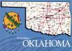
The Oklahoma Digital Map Collection contains over 9,700 maps related to Oklahoma/Indian Territory.
Protective Areas Database of the United States is America’s official national inventory of U.S national forests, national parks and other protected lands.
The Sanborn map collection consists of a uniform series of large-scale maps, dating from 1867 to the present and depicting the commercial, industrial, and residential sections of some twelve thousand cities and towns in the United States, Canada, and Mexico.
The WPA Oklahoma Map Collection During 1935 and 1936, the Works Progress Administration and the Oklahoma Tax Commission produced over 2,400 maps to determine the value of real estate.